
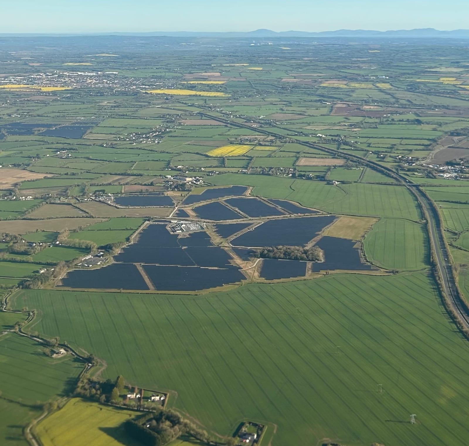
Solar power provides a promising contribution towards the transition to net zero. Solar farm construction is relatively low-impact compared to other energy sources; however, the area required to maximise efficiency presents its own challenges.
Although the foundations for solar panel arrays are relatively minor, even a small solar development will require a significant number of piles or ground screws. For a large development, many thousands could be required across an extensive area, making interference with buried archaeological features a real possibility.
A proactive, pre-design approach to archaeological investigation is therefore strongly recommended. By assessing a site's archaeological potential before finalising layouts — and ideally before submitting a planning application — any mitigation required can be factored in at an early stage, reducing the risk of costly delays later in the project. In some cases, a pre-determination geophysical survey may be requested by the local planning authority as part of the Environmental Impact Assessment process.
In the UK and Ireland, archaeological investigation for solar farm projects follows specific regulations and guidelines established by heritage authorities. The process typically involves several stages, outlined below.
Desk-Based Assessment:
Historical maps, records, and archaeological databases maintained by organisations such as Historic England, Cadw, Historic Environment Scotland, and the National Monuments Service are consulted to identify known archaeological sites or areas of potential significance within the project area.
Collaboration with local planning authorities, archaeological contractors, and heritage agencies provides valuable insights into the area's cultural heritage. The resulting assessment can then inform and target the subsequent stages of investigation.
Field Evaluation:
A field-based walkover survey of the project site is conducted, guided by information obtained during the desk-based assessment, to visually inspect the landscape for signs of archaeological features or artefacts.
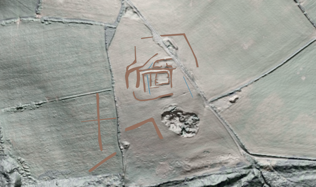
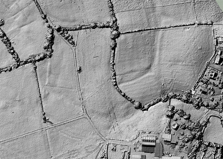
Aerial photography and LiDAR data can also be used to identify potential archaeological sites that may not be visible from the ground. This approach can be further enhanced by using drone-based photogrammetry, which can provide a detailed digital terrain model of the site at approximately 5 cm resolution.
Geophysical Survey:
Geophysical survey is one of the most effective tools for evaluating the archaeological potential of a solar farm site. Magnetic gradiometry is the principal technique used, as it is well suited to detecting the types of features commonly encountered — ditches, pits, kilns, and other cut or fired features — and can cover large areas efficiently, with daily acquisition rates routinely exceeding 20 hectares.
Where ground conditions or site-specific questions require it, complementary techniques such as earth resistance survey or ground-penetrating radar may also be deployed. Modern geophysical survey allows the discovery of archaeological sites and their contextualisation within the wider archaeological landscape, providing a robust evidence base for planning decisions.

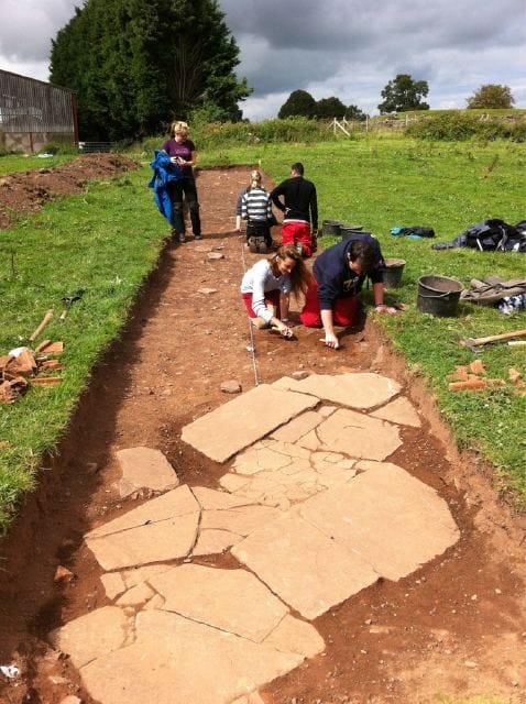
Test trenching:
Test excavations are conducted under the supervision of a qualified archaeologist to investigate features identified by field evaluation or geophysical survey and interpreted as of archaeological origin.
Trenches or test pits are carefully excavated to expose buried archaeology and recover artefacts for analysis. The trenches are then accurately surveyed to record their findings.
Artefact Analysis:
Artefacts recovered during fieldwork undergo specialist analysis — including radiocarbon dating, ceramic analysis, or animal bone analysis — to determine their age, cultural significance, and relationship to the project area's history. Artefact reports are submitted to relevant heritage authorities for review and interpretation.
Report and Mitigation:
Once fieldwork and post-fieldwork processing are completed, a comprehensive report documenting the investigation's findings is compiled, including descriptions of any significant archaeological features or artefacts discovered.
A mitigation plan is then developed in consultation with heritage authorities to address any impacts of the solar farm on the site's archaeological resource. Mitigation measures may include design alterations to preserve archaeology in situ, archaeological monitoring during construction, or further excavation and recording where preservation is not feasible.
Conclusion:
Following these stages ensures a thorough and compliant archaeological investigation for solar farm projects, safeguarding cultural heritage whilst meeting regulatory requirements. A well-planned approach — beginning with early engagement and a clear survey strategy — will expedite planning, reduce project risk, and contribute to a successful outcome.
TerraDat has extensive experience in designing and delivering geophysical surveys for solar farm developments across the UK and Ireland. For help planning a suitable investigation for your site, call us on +44 (0) 2920 700127 or email web@terradat.co.uk.